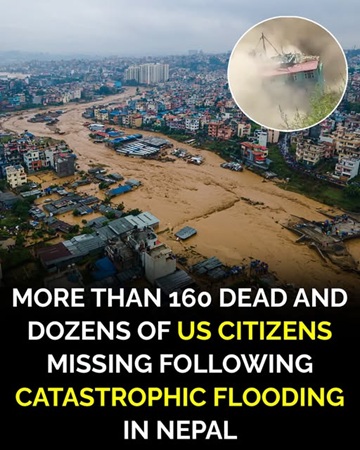
A catastrophic flash flood and debris flow along the mountainous Nepal-Tibet border has caused extensive loss of life, destroyed communities and left large numbers of people unaccounted for. The disaster struck on August 26, 2026, sending an enormous mixture of water, mud, ice, rocks and debris through narrow Himalayan valleys and settlements. Authorities initially reported more than 160 deaths, but the toll increased significantly as search teams reached additional affected areas.
By the following day, Reuters reported that at least 359 people had died and nearly 1,000 remained missing across Nepal and China. Rescue and recovery operations were continuing, meaning casualty figures remained subject to change. Some of the worst destruction on the Nepalese side occurred in and around Rasuwa district, close to the border with Tibet.
The sudden flood moved through river systems with extraordinary force, carrying debris downstream and affecting communities far beyond the location where the initial collapse occurred. Settlements along the Bhote Koshi and Trishuli river systems experienced severe flooding as water and debris moved south. Homes, roads, bridges, businesses and other infrastructure were damaged or destroyed. The mountainous geography made it difficult for emergency teams to reach some locations immediately. Early reports demonstrated how rapidly information changed after the disaster.
Nepal Police initially announced that 162 bodies had been recovered from flood-affected areas across several districts. A later update increased the number to 165 as additional bodies were located. As rescuers continued searching farther downstream and information from previously inaccessible areas became available, the confirmed toll increased substantially. This progression is important because early casualty figures from major natural disasters are frequently incomplete rather than final.
Nepalese authorities mobilized security personnel and emergency teams to conduct search, rescue and recovery operations. Helicopters became particularly important because damaged roads and difficult terrain prevented ground teams from reaching some communities. Search teams worked along river corridors and through areas covered by mud and debris. Their priorities included rescuing survivors, locating missing people, recovering victims and transporting injured residents to medical facilities. Operations were complicated by unstable terrain and widespread infrastructure damage.
Tourists and international visitors were among those caught in the disaster. Nepal is an important gateway for travelers heading toward Himalayan trekking routes and religious destinations, including routes associated with Kailash Mansarovar in Tibet. Many people reported missing after the flooding were traveling through organized tourism or pilgrimage groups. This international dimension meant that governments and diplomatic missions outside Nepal also began working to determine whether their citizens were safe.
The Nepal Tourism Board reported during the early stages of the response that hundreds of tourists could not immediately be accounted for. One Nepalese government update listed 579 tourists as missing, including 466 foreign nationals and 113 Nepalese citizens. Those numbers represented the information available at that particular stage of the search and should not automatically be interpreted as confirmed fatalities. In a rapidly developing emergency, someone listed as missing may later be located safely, rescued or confirmed to have traveled elsewhere.
Different updates also produced different totals for individual nationalities. This is another reason casualty and missing-person figures should be attributed to a particular authority and point in time rather than presented as permanent numbers. Tourism companies, embassies, local authorities and national disaster agencies may initially work with separate passenger lists and registration records. Investigators then need to compare those records and determine whether individuals previously considered missing have made contact.
The United States said its embassy in Kathmandu was working with Nepalese authorities and other organizations to assist affected American citizens. Early reports contained differing estimates for the number of Americans who could not immediately be accounted for. The U.S. State Department therefore avoided treating preliminary numbers as definitive while diplomatic officials continued attempting to establish the status of citizens in the region.
Canadian authorities also monitored developments as reports emerged that Canadian travelers were among those affected. Canadian officials emphasized that overseas registration systems provide useful information during emergencies but do not necessarily reveal exactly how many citizens are physically present in an affected region. Registration is voluntary, meaning some travelers never register while others may remain listed even after their travel plans change. Consequently, registration totals should not be interpreted automatically as casualty or missing-person figures.
Other countries also began trying to establish the whereabouts of their nationals. Travelers from India, Britain, Australia, Malaysia and several other countries were reported among those initially unaccounted for. Many were visiting the region as tourists or pilgrims. Diplomatic officials and tour operators worked with local authorities to compare travel records and determine who had been located.
India was particularly affected because of the large number of Indian travelers who visit Himalayan religious destinations. Authorities in Indian states near Nepal were also placed on alert as the consequences of the flooding became clearer. The disaster demonstrated how a major event in the Himalayan river system can quickly become an international emergency because rivers, transportation networks and tourism routes cross national boundaries.
On the Tibetan side of the border, severe destruction was also reported. Chinese authorities reported casualties and hundreds of missing people, including foreign visitors. Gyirong, an important border area connecting Tibet with Nepal, was among the locations badly affected. Buildings, vehicles and infrastructure were struck by the rapidly moving debris flow. Rescue teams faced many of the same difficulties encountered on the Nepalese side, including damaged access routes and unstable terrain.
Images and video from affected areas showed the extraordinary physical power of the event. Large quantities of mud and debris moved through valleys and around buildings, while vehicles and infrastructure were overwhelmed by the surge. Such images can help document the scale of a natural disaster, but they do not by themselves establish casualty numbers or explain the geological cause. Official investigations and verified assessments remain necessary for those conclusions.
One of the most important developments concerned the cause of the disaster. Early information suggested that seismic activity might have been connected to the flooding. The U.S. Geological Survey initially registered what appeared to be an earthquake signal near the Nepal-China border. Further analysis, however, produced a substantially different conclusion.
The USGS examined information from nearby seismic stations, long-period seismic waves and satellite imagery. Its subsequent assessment determined that the signal had not been produced by an earthquake. Instead, the agency concluded that a glacial collapse and accompanying debris flow generated the event. This correction is important because repeating the original earthquake explanation after the scientific assessment changed would create an inaccurate account of what happened.
Satellite imagery subsequently provided additional evidence about the scale of the collapse. Analysis reported by the Associated Press indicated that a section of glacier and underlying bedrock collapsed in the Himalayan mountains. Huge quantities of ice, rock and other material then traveled downhill. As that material entered the drainage system, it contributed to a destructive surge capable of carrying additional sediment and debris downstream.
The geography of the Himalayan region can make events of this type particularly dangerous. Steep mountain slopes allow collapsing material to accelerate rapidly, while narrow valleys can concentrate water and debris. Once the moving material enters a river system, communities located considerable distances downstream can face danger with relatively little warning. Roads and settlements are also frequently concentrated along valleys because mountainous terrain provides limited space for construction.
Reports indicated that the initial surge entered the Lhende Khola before moving into the Bhote Koshi and eventually the Trishuli river system. Water levels reportedly increased dramatically within a short period. Communities downstream therefore faced not simply ordinary river flooding but a fast-moving mixture containing sediment, rocks and other debris. That combination can produce much greater destructive force than water alone.
The flooding caused major damage to transportation infrastructure. Government assessments reported dozens of bridges damaged, including both motorable and suspension bridges. Significant sections of roads were also affected. Losing roads and bridges creates an additional emergency after the initial flood because rescuers may be unable to reach isolated communities using conventional vehicles.
Infrastructure damage also affected electricity and hydropower facilities. Nepal relies heavily on hydropower, and facilities located along rivers can be particularly vulnerable to major floods and landslides. Damage to transmission systems or generating infrastructure can disrupt electricity supplies while simultaneously complicating recovery efforts. Authorities therefore had to evaluate both immediate humanitarian needs and longer-term infrastructure consequences.
The destruction of roads also created economic concerns. Border routes between Nepal and Tibet carry travelers as well as commercial traffic. Damage to customs facilities, bridges and transportation corridors can interrupt trade long after rescue operations end. Families whose livelihoods depend on tourism, transportation or local businesses may therefore experience economic consequences even if their homes were not directly destroyed.
For residents of affected communities, however, the immediate priority remained finding relatives and neighbors. Families searched hospitals, evacuation areas and emergency centers for information about people who had disappeared during the flood. Some survivors described being separated from relatives when the surge arrived. Others escaped while homes and nearby structures were swept away or buried.
Search teams faced an enormous physical challenge. Mud and debris can cover large areas and make it difficult to determine where buildings, vehicles or people were located before a flood. Heavy equipment may not be immediately available in isolated mountain communities. Even when equipment can be transported into the area, unstable slopes and damaged roads can make operating it dangerous.
Helicopters therefore became essential to portions of the response. Nepalese military helicopters were used to evacuate people from locations that could not easily be reached by road. One government update reported that more than 100 people, including Nepalese and foreign nationals, had been rescued by helicopter from the Timure area. Air operations also helped transport supplies and emergency personnel.
Weather and geography remained continuing concerns. Mountain conditions can change quickly, while additional rainfall can destabilize slopes already weakened by a major debris flow. Emergency officials therefore needed to consider the safety of rescuers as well as survivors. Sending personnel into an unstable valley without assessing continuing hazards could expose rescue teams to another landslide or flood.
Authorities also monitored the possibility of additional flooding. Large landslides and debris flows can create temporary natural dams when rocks, mud and ice block rivers. Water can accumulate behind those blockages until the temporary dam fails, potentially producing another sudden downstream surge. Monitoring upstream conditions therefore became an important part of protecting communities and rescue personnel.
Residents near vulnerable riverbanks were urged to move away from potentially dangerous areas. Such warnings were precautionary measures intended to reduce additional casualties while authorities assessed changing river conditions. People living downstream from mountain disasters can remain vulnerable even after the first surge has passed because unstable debris may continue altering normal water flow.
The disaster has also drawn attention to the broader vulnerability of Himalayan communities to glacier-related hazards. The Hindu Kush Himalayan region contains tens of thousands of glaciers and provides water to major river systems supporting enormous populations. Glaciers naturally change over time, but scientists have documented substantial warming and ice loss across the region.
Climate change is an important part of the broader scientific discussion about Himalayan glacier stability, although researchers must distinguish long-term trends from conclusions about the precise cause of an individual collapse. Scientists have warned that rising temperatures can contribute to glacier retreat, thawing permafrost and unstable mountain slopes. Those changes can increase certain types of hazards involving ice, rock, landslides and glacial lakes.
For this particular disaster, preliminary geological assessments identified a major glacier and rock collapse as the trigger. Determining every factor that contributed to the collapse requires more detailed scientific investigation. It would therefore be premature to assign every aspect of this individual event to one cause before those investigations are completed.
What scientists can say more confidently is that the Himalayan environment is undergoing significant change. Warming temperatures have affected glaciers throughout the region, and researchers have repeatedly emphasized the importance of improved monitoring. Satellite observations, river gauges, seismic instruments and early-warning networks can help authorities identify some developing hazards.
Early-warning systems cannot prevent a glacier from collapsing, but they can sometimes provide communities downstream with valuable time to move to safer locations. Even a relatively short warning can matter when a destructive surge is traveling through a river valley. Effective systems require not only scientific instruments but also reliable communication networks and evacuation procedures that communities understand.
The Nepal-Tibet disaster illustrates how difficult this challenge can become. A collapse high in a remote mountain area can develop into a major flood before people many kilometers downstream understand what has happened. Telecommunications and electricity may then fail just when accurate information becomes most important. Damaged roads can further isolate communities after the event.
International assistance and cooperation can therefore become particularly valuable. Nepal has extensive experience responding to earthquakes, landslides, floods and other natural hazards, but an event affecting large areas can overwhelm local resources. Humanitarian organizations can provide emergency shelter, clean water, medical assistance and other supplies while government agencies concentrate on rescue and infrastructure.
Foreign governments also have responsibilities toward their citizens traveling in affected areas. Embassies can communicate with local authorities, contact tour companies and help relatives obtain reliable information. They can also provide consular assistance to citizens who have lost travel documents or need help leaving an affected region.
At the same time, uncertainty should be communicated clearly. A person appearing on a missing list is not automatically confirmed dead. Travel groups can become separated during evacuations, mobile networks can fail, and people may reach safety without immediately contacting authorities. Missing-person totals can therefore decrease as communication is restored.
The opposite is also possible with confirmed casualty numbers. Death tolls can rise as rescuers reach previously inaccessible locations and recover victims. This is what happened during the first day of reporting from Nepal, when the initial confirmed toll increased repeatedly. Responsible reporting should therefore identify figures as current estimates rather than imply that they are final.
Another challenge involves information circulating through social media. Dramatic images from natural disasters can spread globally within minutes, sometimes before authorities understand what has happened. Genuine photographs and videos may be mixed with older material from unrelated events. Unverified casualty figures can also spread rapidly and continue circulating after official numbers have changed.
For that reason, information from police, disaster-management authorities, scientific agencies and established news organizations is particularly important during an evolving emergency. Even official information can change as new evidence becomes available, as demonstrated by the initial earthquake interpretation that was later corrected. Updating information when better evidence emerges is part of accurate reporting.
The distinction between the early earthquake theory and the later glacial-collapse assessment is particularly instructive. Seismic instruments can record signals generated by processes other than conventional earthquakes. Large landslides, avalanches and glacier collapses can create vibrations detectable by seismic stations. Scientists must analyze the characteristics of those signals alongside other evidence before determining their origin.
Satellite imagery provided another important source of evidence. Comparing images taken before and after the disaster allowed researchers to examine changes to the glacier, mountain slopes and river channels. Such observations can help reconstruct how material moved through the landscape and identify where the initial collapse occurred.
The river itself was dramatically transformed in some locations. Large debris flows can widen channels, deposit enormous quantities of sediment and redirect water. These physical changes can create continuing hazards and complicate reconstruction. A road or bridge cannot simply be rebuilt in exactly the same location if the river channel has fundamentally changed.
Recovery will consequently extend far beyond the immediate search operation. Communities will need homes repaired or rebuilt, roads restored, bridges replaced and essential services reconnected. Schools, businesses and health facilities may also require reconstruction. Agricultural land covered by sediment can take additional time to recover.
Tourism could also experience significant disruption. Himalayan communities often depend economically on visitors, trekking groups and pilgrims. Damaged transportation routes can prevent tourists from returning even to communities that escaped the worst physical destruction. Businesses dependent on seasonal visitors may therefore face months or longer without normal income.
The human consequences are more difficult to measure. Survivors may have lost relatives, homes, businesses and possessions simultaneously. Families waiting for news about missing loved ones face additional uncertainty. Community recovery therefore involves emotional and social needs as well as rebuilding physical infrastructure.
International attention will inevitably decrease as the immediate emergency passes, but recovery in affected communities is likely to continue much longer. Reconstructing mountain infrastructure is expensive and technically challenging. Future construction may also need to account for changed river channels and newly identified hazard zones.
Scientists are likely to study the event carefully because understanding its mechanics could improve future hazard assessments. Researchers can examine satellite imagery, seismic records, weather data and field evidence to reconstruct the sequence of events. Those findings may help identify similar vulnerable locations elsewhere in the Himalayas.
The tragedy also demonstrates why precise language matters when describing natural disasters. Calling the event simply a flood does not fully explain the combination of glacier collapse, rock, sediment, water and downstream debris movement involved. At the same time, technical explanations should not be used to claim certainty where investigations are still continuing.
As rescue and recovery operations continue, authorities remain focused on locating missing people and supporting survivors. Confirmed numbers may continue changing as teams reach additional areas and reconcile different lists of residents, tourists and travelers. Updates from official agencies therefore remain more reliable than fixed numbers copied from earlier reports.
The central facts are already clear despite those changing figures. A major glacier and rock collapse generated a catastrophic debris flow and flash flooding through the Nepal-Tibet border region. Hundreds of people have died, many others remain unaccounted for, and communities and infrastructure have suffered extensive destruction.
The disaster has affected people from numerous countries, but its greatest impact is being experienced by communities directly along the affected Himalayan valleys. For residents, the event represents far more than international casualty statistics. Homes, livelihoods, transportation routes and familiar landscapes have been transformed in a matter of minutes.
For travelers and their families, uncertainty remains another painful part of the emergency. Authorities continue trying to establish the status of people initially listed as missing. Until individual cases are confirmed, it is important not to describe missing travelers as fatalities or make assumptions about their circumstances.
For scientists, the event provides another urgent example of the hazards associated with unstable high-mountain environments. Further research will be required to understand exactly why the glacier and underlying rock failed when they did. That investigation may eventually provide information that helps improve monitoring elsewhere.
For emergency authorities, attention remains centered on immediate priorities: finding survivors, recovering victims, delivering medical assistance, restoring access and protecting people from additional hazards. Those tasks are complicated by the same mountainous landscape that makes the Himalayan region both remarkable and difficult to navigate.
As more verified information becomes available, the complete scale of the Nepal-Tibet disaster will become clearer. Until then, casualty and missing-person totals should be understood as evolving figures rather than final conclusions. The most responsible account is one that updates those numbers when authorities provide new information and avoids filling gaps with speculation